List of Villages under PMRDA
About Pune Metropolitan Region Development Authority (PMRDA)
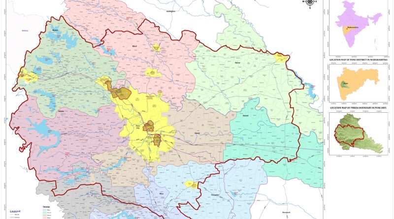
The Pune Metropolitan Region Development Authority (PMRDA) serves as the official entity overseeing the ongoing plans and development activities throughout the Pune Metropolitan Region. Established in the first quarter of 2015, this authority has jurisdiction over an expansive area of 7,256.46 km2 or 2,801.73 square meters. With a population of approximately 7.276 million people residing within this region, PMRDA stands as the largest urban unit in Maharashtra. The Government of Maharashtra has formally established PMRDA as a legally empowered corporate body with the aim of promoting sustainable development.
| S.N. | Taluka | Number of Villages under PMRDA |
| 1 | Daund | 51 |
| 2 | Bhor | 53 |
| 3 | Haveli | 108 |
| 4 | Khed | 114 |
| 5 | Maval | 189 |
| 6 | Mulashi | 144 |
| 7 | Shirur | 68 |
| 8 | Purandar | 38 |
| 9 | Velhe | 52 |
| Total | 817 |
About Bhor Taluka:
Bhor Taluka is recognized for its agricultural pursuits and features a blend of rural and semi-urban zones. The administrative headquarters of the taluka are situated in the town of Bhor. The local economy predominantly revolves around agriculture, and the residents are actively involved in farming and associated occupations.
Bhor on Map:
List of villages from Bhor Taluka under PMRDA:
- Bhambavade
- Bhongavli
- Degaon
- Dhangawadi
- Didghar
- Divale
- Gunand
- Hrishchandri
- Jambhali
- Kambare
- Kamthadi
- Kanjale
- Kapurhol
- Karandi
- Kasurdi
- Kelavade
- Kenjal
- Ketkavane (Nimme)
- Khadki
- Khopi
- Kikavi
- Kolavadi
- Kurungvadi
- Kusgaon
- Malegaon
- Morwadi
- Nasrapur
- Naygaon
- Nhavi
- Nidhan
- Nigade
- Pande
- Panjalwadi
- Parvadi
- Rajapur
- Ranje
- Salavade
- Sangavi Bk.
- Sangavi Kh.
- Sarole
- Sasewadi
- Savardare
- Shindewadi
- Shivare
- Sonavadi
- Taprewadi
- Umbare
- Varve Bk.
- Varve Kh.
- Vathar Kh.
- Velu
- Virwadi
- Wagajwadi
About Daud Taluka:
Daund taluka is a subdivision located in the Pune district of the state of Maharashtra, India. The town of Daund stands as the sole major urban area in this primarily rural region. Daund railway station plays a significant role as a major railway junction. It serves as a connecting point for all southern railways, linking routes to northern Indian railways, including destinations like Delhi and Solapur division. The railway line divides at Daund junction before merging with the Pune district junction.
Daud on Map:
List of villages in Daud Taluka:
- Amoni Mal
- Bhandgaon
- Bharatgoan
- Boratewadi
- Boriaindi
- Boribhadak
- Boripardhi
- Dahitane
- Dalimb
- Dapodi
- Delvadi Ekeriwadi
- Deshmukh Mala
- Devkarwadi
- Dhaygudewadi
- Dhumalicha Mala
- Galandwadi
- Ganesh Road
- Handalwadi
- Jawjebuwachiwadi
- Kamatwadi
- Kasurdi
- Kedgaon
- Kedgaon Station
- Khamgaon
- Khopodi
- Khutbav
- Koregaon Bhiwar
- Ladkatwadi
- Mirwadi
- Nandur
- Nangaon
- Nathachiwadi
- Nimbalkar Wasti
- Panwali
- Pargaon
- Patethan
- Pilanwadi
- Pimpalgaon
- Rahu
- Sahajpurwadi
- Takali
- Tambewadi
- Tamhanwadi
- Telewadi
- Undavadi
- Vadgaon Bande
- Valki
- Varwand
- Wakhari
- Yawat
- Yawat Station
About Haveli Taluka:
Haveli Taluka is a division within the Pune district of Maharashtra, India. The Pune Municipal Corporation and Pimpri Chinchwad Municipal Corporation are centrally located within and entirely encircled by the taluka for administrative purposes. The larger portion of the region falls under the Pune Metropolitan Region. As of the 2011 census, the taluka had a population of 2,435,581, with 1,823,950 individuals residing in urban areas and 611,631 in rural areas. This demographic breakdown indicates that a substantial majority, approximately 75% of the population in Taluka Haveli, lives in urban areas.
Haveli on Map:
List of Villages from Haveli under PMRDA:
- Aambi
- Agalambe
- Alandi Mhatobachi
- Arvi
- Ashtapur
- Autad Handewadi
- Avasare
- Awhalwadi
- Bahuli
- Bakori
- Bhagatwadi
- Bhavadi
- Bhilarewadi
- Bhowarapur
- Bivari
- Burkegaon
- Dehu
- Donaje
- Dongargaon
- Gaud Dara
- Gawadewadi
- Ghera Sinhgad
- Gogalwadi
- Gorhe Bk.
- Gorhe Kh.
- Hingangaon
- Holkarwadi
- Jambhali
- Jambhulwadi
- Kadamvak Wasti
- Kalyan
- Kesnand
- Khadakwadi
- Khadakwasale
- Khadewadi
- Khamgaon Mawal
- Khamgaon Tek
- Khanapur
- Khed Shivapur
- Kirkitwadi
- Kolavdi
- Kolavdi(Ambegaon Kh. Khalil)
- Kondhanpur
- Kondhave Dhavade
- Kopare
- Koregaon Mul
- Kudaje
- Kunjirwadi
- Loni-kalbhor
- Loni-kand
- Malinagar
- Malkhed
- Mandavi Bk.
- Mandavi Kh.
- Manerwadi
- Mangewadi
- Manjari Bk.
- Manjari Kh.
- Mogarwadi
- Mokarwadi
- Mordarwadi
- Murkutenagar
- Nanded
- Nandoshi
- Narhe
- Naygaon
- Nhavi Sandas
- Nimbalkarwadi
- Nirgudi
- Perane
- Peth
- Phulgaon
- Pimpari Tarf Sandas
- Pisoli
- Rahatvade
- Ramnagar
- Ramoshiwadi
- Sambharewadi
- Sanas Nagar
- Sangarun
- Sangavi Tarf Sandas
- Sashte
- Shevalwadi
- Shindewadi
- Shindwane
- Shiraswadi
- Shivapur
- Sonapur
- Sortapwadi
- Taleranwadi
- Tanhaji Nagar
- Tarade
- Theur
- Thoptewadi
- Tikekarwadi
- Tulapur
- Uruli Kanchan
- Vadachiwadi
- Vadaki
- Vadgaon Shinde
- Vardare
- Vitthal Nagar
- Wade Bolhai
- Wadhu Kh.
- Wagholi
- Walati
- Wanjalewadi
- Prayagdham
- Mokarwadi
- Khadewadi
- Wanjalewadi
About Khed Taluka:
Khed taluka, situated near Pune city in the Pune district of Maharashtra, India, is a tehsil within the subdivision. Rajgurunagar serves as the headquarters of this taluka. Renowned as the birthplace of Santaji Jagnade, the city is named Rajgurunagar in honor of Shaheed Shivram Hari Rajguru. According to the 2001 India census, Khed Taluka had a population of 343,214.
Khed on Map:
List of Villages from Khed Taluka under PMRDA:
- Ahire
- Akharwadi
- Alandi
- Ambethan
- Arudewadi
- Askhed Bk.
- Askhed Kh.
- Bahirwadi
- Bahul
- Bhamboli
- Bhose
- Biradwadi
- Butewadi
- Chandoli
- Chandus
- Charholi Kh.
- Chas
- Chaudharwadi
- Chichbaiwadi
- Chimbali
- Chinchoshi
- Davadi
- Dhamane
- Dhanore
- Dhorewadi
- Donde
- Gadakwadi
- Gargotiwadi
- Golegaon
- Gonvadi
- Gosasi
- Gulani
- Hedruj
- Holewadi
- Jaidwadi
- Jaulke Bk.
- Jaulke Kh.
- Kadachiwadi
- Kadus
- Kalewadi
- Kalus
- Kaman
- Kanersar
- Kanhewadi Tarf Chakan
- Karanj Vihire
- Kelgaon
- Khalchi Bhamburwadi
- Khalumbrae
- Kharabwadi
- Kharpudi Bk.
- Kharpudi Kh.
- Kiwale
- Kohinde Bk.
- Kohinkarwadi
- Koregaon Bk.
- Koregaon Kh.
- Koyali Tarf Chakan
- Koye
- Kurkundi
- Kuruli
- Mahalunge
- Manjarewadi
- Markal
- Medankarwadi
- Mirajewadi
- Moi
- Nanekarwadi
- Nighoje
- Nimgaon
- Pacharnewadi
- Padali
- Pait
- Pangari
- Papalwadi
- Parale
- Pimpalgaon Tarf Chakan
- Pimpalgaon Tarf Khed
- Pimpari Bk.
- Pimpari Kh.
- Pur
- Rakshewadi
- Rase
- Raundhalwadi
- Retavadi
- Rohakal
- Sabalewadi
- Sandbhorwadi
- Sangurdi
- Santosh Nagar
- Satkarsthal
- Sawardari
- Shelgaon
- Shelu
- Shinde
- Shiroli
- Shive
- Sidhegavhan
- Solu
- Takalkarwadi
- Talawade
- Torne Bk
- Vadgaon Ghenand
- Vadgaon Tarf Khed
- Warale
- Warchi Bhamburwadi
- Warude
- Vaphgaon
- Wahagaon
- Wakalwadi
- Waki BK
- Waki Kh.
- Waki Tarf Wada
- Wasuli
- Yevalewadi
About Maval Taluka:
Maval taluka is located in the Mawal subdivision of the Pune district in the state of Maharashtra, India. As per the 2011 Census of India, this taluka consisted of a total of 187 villages.
Maval on Map:
List of Villages in Maval Taluka under PMRDA:
- Adhale bk
- Adhale kh.
- Adhe kh.
- Ahirvade
- Ajivali
- Akurdi
- Ambale
- Ambegaon
- Ambi
- Apati
- Ardav
- Atvan
- Aundhe kh.
- Aundholi
- Badhalawadi
- Baur
- Bebad Ohol
- Bedse
- Belaj
- Bhadawali
- Bhaje
- Bhajgaon
- Bhoyre
- Boraj
- Boravli
- Brahman Wadi
- Brahmanoli
- Brahmanwadi
- Brahmanwadi Baur
- Budhavadi
- Budhle N.M
- Chandkhed
- Chavsar
- Chikhalse
- Dahiwali
- Dahuli
- Darumbare
- Devale
- Devghar
- Dhalewadi
- Dhamne
- Dhangavhan
- Divad
- Done
- Dongargaon
- Dudhivare
- Fagane
- Gahunje
- Gevhande (Khadak)
- Gevhande Apati
- Ghonshet
- Godumbare
- Govitri
- Indori
- Inglun
- Jadhavwadi
- Jambavade
- Jambhul
- Jamboli
- Jeware
- Jovan
- Kacharewadi
- Kadadhe
- Kadav
- Kale
- Kalhat
- Kambare Andar
- Kambare N.m.
- Kamshet
- Kanhe
- Karandoli
- Karanjgaon
- Karla
- Karunj
- Kashal
- Keware
- Khadkale (CT)
- Khand
- Khandshi
- Kiwale
- Kolechafesar
- Kondivade N.m
- Kondiwade
- Kothurne
- Kune N.m.
- Kunewadi
- Kurvande
- Kusavli
- Kusgaon Bk. (CT)
- Kusgaon Kh.
- Kusgaon P.m.
- Kusur
- Lohagad
- Mahagaon
- Majgaon
- Malavandi Thule
- Malawadi
- Malawali P.m. ( Dhore)
- Malegaon Bk.
- Malegaon Kh.
- Malewadi
- Malvali
- Mangarul
- Mau
- Mendhewadi
- Mohitewadi
- Moramarvadi
- Morave
- Mudhavare
- Nagatali
- Nandgaon
- Nane
- Nanoli N.m.
- Nanoli Tarf Chakan
- Naygaon
- Nesave
- Nigade
- Ovale
- Ozarde
- Pachane
- Pale
- Pale Nane Mawal
- Pangloli
- Pansoli
- Parandwadi
- Paravadi
- Patan
- Pathargaon
- Pawalewadi
- Phalne
- Pimpal Khunte
- Pimploli
- Pimpriwadi
- Prabhachiwadi
- Pusane
- Rajpur
- Rakaswadi
- Sadapur
- Sadavli
- Sai
- Salumbe
- Sangavade
- Sangavi
- Sangise
- Sate
- Sawale
- Sawantwadi
- Shevati
- Shilatane
- Shilimb
- Shindgaon
- Shirde
- Shire
- Shirgaon
- Shivali
- Shivane
- Somatane
- Somwadi
- Sudawadi
- Sudumbare
- Taje
- Takave Bk.
- Takave Kh.
- Talegaon Dabhade (R)
- Thakursai
- Thoran
- Thugaon
- Tikona
- Tung
- Udhewadi
- Uksan
- Umbare Navalakh
- Urse
- Vadavali
- Vadeshwar
- Vadivale
- Vagheshwar
- Valak
- Valvanti
- Varale
- Varsoli
- Varu
- Vaund
- Vehergaon
- Velholi
- Wahangaon
- Waksai
- Yelghol
- Yelse
About Mulashi Taluka:
Mulshi taluka is situated in the Maval subdivision of the Pune district in the state of Maharashtra, India. It encompasses both the Pune Metropolitan Region and various villages. As indicated by the 2011 Census of India, Taluka Mulshi is home to a population of 171,006. The taluka is predominantly rural, with the majority of its residents residing in rural areas. Urban areas in this taluka are home to 25,633 people.
Mulashi on Map:
List of Villages from Mulashi Taluka under PMRDA:
- Adgaon
- Admal
- Akole
- Amaralewadi
- Ambarwet
- Ambawane
- Ambegaon
- Aandesh
- Andgaon
- Andhale
- Asade
- Barpe Bk.
- Bavdhan Bk.
- Belwade
- Bhadas Bk.
- Bhalgudi
- Bhambarde
- Bhare
- Bharekarwadi
- Bhegdewadi
- Bhembatmal
- Bhode
- Bhoirwadi
- Bhugaon
- Bhuini
- Bhukum
- Botarwadi
- Chale
- Chande
- Chandivali
- Chikhalgaon
- Chikhali Bk.
- Chinchwad
- Dakhane
- Darawali(Dakhli)
- Dasave
- Dattawadi
- Davje
- Devghar
- Dhadavali
- Dhamanohol
- Disali
- Dongargaon
- Ekole
- Gadhale
- Gawadewadi
- Ghotavade
- Ghutake
- Godambewadi
- Hadasi
- Hinjavadi
- Hotale
- Hulavalewadi
- Jambe
- Jamgaon
- Jatede
- Javal
- Kalamshet
- Karmoli
- Kasar Amboli
- Kasaresai Shindewadi
- Kashing
- Katar Khadak
- Kathavadi
- Kaubawali
- Kemasewadi
- Khamboli
- Kharvade
- Khechre
- Kolavali
- Koloshi
- Kolvade
- Kolwan
- Kondhavle
- Kondhur
- Kule
- Kumbheri
- Lavale
- Lavarde
- Mahalunge
- Male
- Malegaon Dattwadi
- Man
- Mandede
- Manrnewadi
- Marunji
- Masgaon
- Materwadi
- Morewadi
- Mose Kh.
- Mugaon
- Mugavde
- Mukhaiwadi
- Mulkhed
- Mulshi Kh.
- Muthe
- Nande
- Nandgaon
- Nandivali
- Nanegaon
- Nere
- Nive
- Padalghar
- Padalgharwadi
- Palase
- Patharshet
- Paud
- Peth Shahapur
- Pimploli
- Pimpri
- Pirangut
- Pomgaon
- Ravade
- Rihe
- Saiv Kh
- Sakhari
- Saltar
- Sambhave
- Sathesai
- Savargaon
- Shedani
- Shere
- Shileshwar
- Shirvali
- Sus
- Tail Baila
- Tamhini Bk
- Tata Talav
- Tav
- Temghar
- Ugavali
- Uravade
- Vadgaon
- Valane
- Vandre
- Vatonde
- Vede
- Vegre
- Visakhar
- Vitthalwadi
- Wadavali
- Walen
- Wanjale
- Warak
About Purandar Taluka:
Purandar taluka, located in the Pune district of the state of Maharashtra, India, is characterized by 108 villages and 3 towns. According to the 2011 Census of India, the population of Purandar Taluka is recorded at 235,659.
Purandar on Map:
List of Villages from Purandar Taluka under PMRDA:
- Ambodi
- Askarwadi
- Bahirwadi
- Bhivadi
- Bhivari
- Bhopgaon
- Bohalewadi
- Chambali
- Chivhewadi
- Devadi
- Dive
- Garade
- Gherapurander
- Gurholi
- Hivare
- Jadhavwadi
- Kalewadi
- Ketkawale
- Kodit Budrukh
- Kodit Kh.
- Kumbharvalan
- Kumbhoshi
- Misalwadi
- Panvadi
- Patharwadi
- Pawarwadi
- Pimpale
- Pokhar
- Pur
- Singapur
- Somurdi
- Sonori
- Supe Kh.
- Thapewadi
- Udachiwadi
- Vanpuri
- Warwadi
- Zendewadi
About Shirur Taluka:
Shirur taluka is a subdivision within the Haveli subdivision of Pune district in the state of Maharashtra, India. This town is positioned along the banks of the Ghod River and was known as Ghodnadi in the 20th century. Situated on the border of Pune and Ahmed Nagar districts, it serves as a primary trading center for both Shirur Taluka and Parner Taluka in Ahmed Nagar District.
The town boasts well-established schools and colleges, attracting a diverse population with varying religious beliefs. Within the taluka, there are three sugar factories, and the renowned Ranjangaon MIDC hosts numerous multinational manufacturing companies.
Shirur on Map:
List of Villages from Shirur Taluka under PMRDA:
- Alegaon Paga
- Arangaon
- Ambale
- Amdabad
- Andhalgaon
- Apti
- Babhulsar Kh.
- Bhambarde
- Chavhanwadi
- Chincholi
- Shastabad
- Dahiwadi
- Darekarwadi
- Dhamari
- Dhanore
- Dhok Sangavi
- Dingrajwadi
- Ganegaon
- Golegaon
- Hivare
- Jategaon Bk.
- Jategaon Kh.
- Kanhur mesai
- Karade
- Karandi
- Karanjawane
- Karegaon
- Kasari
- Kendur (Mahadev wadi, Parhadwadi, Sukrewadi, Tithewadi)
- Khairewadi (Khaire Nagad)
- Khandale
- Kondhapuri
- Koregaon Bhima (CT)
- Malthan
- Lakhewadi
- Midgulwadi
- Motewadi
- Mukhai
- Nagargaon
- Nhavara
- Kohakdewadi
- Nimgaon Bhogi
- Nimgaon Mhalungi
- Nimone
- Pabal (Chudharibend Wasti, Thapewadi Pimpalwadi, Futanwadi Akharimal, Malwadi Agarkarwad)
- Parodi
- Shivtakrar Mahalungi
- Pimpale Jagtap
- Pimpale Dumal
- Pimpari Dumala
- Ranjangaon Ganpati
- Ranjangaon Sandas
- Rakshewadi
- Sanaswadi (CT)
- Shikrapur
- Rautwadi
- Shirur (Annapur, Saradwadi, Tardobachiwadi, Kardilwadi)
- Sone Sangavi
- Takali Bhima
- Talegaon Dhamdhere
- Uralgaon
- Varude
- Shingadwadi
- Vitthalwadi
- Vadu Bk.
- Waghale
- Wajewadi
- Burunjawadi
About Velhe Taluka:
Velhe Taluka is situated in the Haveli subdivision of Pune district in the state of Maharashtra, India. This taluka is entirely rural in nature, encompassing a total of 130 villages. According to the 2011 Census of India, Velhe Taluka is home to a population of 54,516 people.
Velhe on Map:
List of Villages from Velhe Taluka under PMRDA:
- Adavali
- Ambavane
- Ambed
- Ambegaon Bk
- Ambegaon Kh.
- Askawadi
- Bhalvadi
- Boravale
- Chikhali kh.
- Chinchale Bk.
- Chinchale Kh.
- Dapode
- Dhindli
- Ghodshet
- Gholapghar
- Givashi
- Kandave
- Kambegi
- Kranjwane
- Kasedi
- Kathawadi
- Ketkavane
- Khambawadi
- Khamgaon
- Kolwadi
- Kondgaon
- Koshimghar
- Kuran Bk
- Kuran Kh
- Kurvathi
- Lashirgaon
- Malavli
- Mangaon
- Mangdari
- Margasani
- Mose Bk
- Nigade
- Nigade Bk.
- Osade
- Panshet
- Pole
- Ranjane
- Ranavdi
- Rule
- Saiv Bk.
- Shirkoli
- Thangaon
- Vadghar
- Wanjalwadi
- Varasgaon
- Vinzar
- Wangani
FAQs about Villages under PMRDA
What does PMRDA stand for?
PMRDA is an acronym for Pune Metropolitan Region Development Authority, the official body overseeing planning and development in the Pune Metropolitan Region.
How many villages fall under the jurisdiction of PMRDA?
817 Villages
What is the objective of PMRDA in rural areas?
PMRDA aims to foster sustainable development in both urban and rural areas within its purview. In rural regions, this involves infrastructure enhancement, agricultural initiatives, and overall improvement of living standards.
What types of development projects are initiated in PMRDA villages?
Development projects in PMRDA villages encompass improvements in infrastructure (roads, water supply, sanitation), agricultural programs, community development initiatives, and other projects to elevate the overall quality of life.
How can residents in PMRDA villages benefit from PMRDA’s efforts?
Residents can experience benefits through upgraded infrastructure, improved amenities, increased livelihood opportunities, and overall socio-economic development.