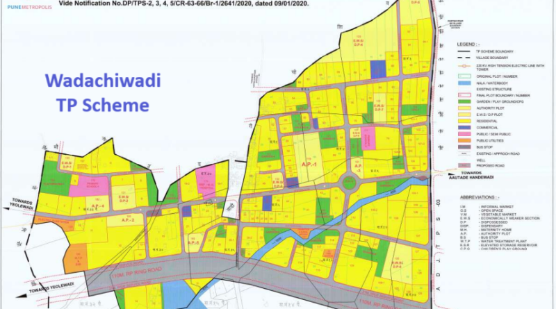
Wadachiwadi Town Planning (TP) Scheme in Pune – PMRDA Infra Project
As per the Pune Metropolitan Region Development Authority (PMRDA), this town planning scheme covers an expanse of 134 hectares, including 2.95 hectares around the Nullah. Upon completion, landowners are slated to receive 148 developed plots through this scheme. Additionally, 11.72 hectares have been allocated for economically disadvantaged sections (EWS). The ring road is designated to utilize 19 hectares of land.
A specific allocation of 15.50 hectares is earmarked for internal roads, 7 plots for open grounds, and 11 plots for various gardens. PMRDA has strategically planned the Wadachiwadi Town Planning Scheme to facilitate the development of the Inner Ring Road within the PMRDA area. The declaration of intent to formulate the scheme was executed under the provisions of the Maharashtra Regional and Town Planning Act, 1966 (MRTP) under section 60(1) on 17/12/2018.
Wadachiwadi has been incorporated into the Pune Municipal Corporation (PMC) Limit, with PMRDA appointed as the Special Planning Authority for the region. The comprehensive town planning scheme envisages the integration of a primary health center, a sewage treatment plant, a fire station, bus stops, a vegetable market, and a shopping center.
These town planning schemes are designed as revenue models to support the proposed 128-km PMRDA Inner Ring Road. It is anticipated that a total of 26 town planning schemes will be implemented along the initial 32 km stretch of the proposed Pune Ring Road. Importantly, landowners are not required to relocate; instead, they become integral contributors to the development process. This approach is envisioned to benefit the entire community, as planning authorities can efficiently undertake essential infrastructure projects.
The Connectivity to Wadachiwadi from State Highway (S.H 116), Katraj to Fursungi. The TPS is located about 2 km. from this State Highway. Also connecting through with Major District Road (MDR.136) and Village Road VR154. A 6m wide existing/approach road connects TPS with Gaonthan at North direction and further it connects to Katraj-Hadapsar Bypass Road at a distance of 1.5 Km in North direction.
The distribution of the total area of final plots in the allocation is as follows:
- Total Area of Final Plots Allotted to Landowners: 67.50 hectares (51.20%)
- Total Area of Final Plots Allotted to PMRDA: 38.98 hectares (25.09%)
- Total Area of Final Plots Allotted to PMRDA for Open Spaces, Garden, Lake Development: 11.86 hectares (9.00%)
- Total Area of Final Plots Allotted for Public Amenities and Utilities: 06.53 hectares (4.95%)
- Total Area of Final Plots Allotted to PMRDA for Sale: 08.87 hectares (6.73%)
- Total Area of Final Plots Allotted to PMRDA for Economically Weaker Sections (E.W.S): 11.72 hectares (8.89%)
Additionally, specific allocations include:
- Area under Road: 25.33 hectares (19.22%)
- 110m Ring Road: 16.60 hectares (1.51 km) (12.65%)
- 18m, 12m, 9m Wide TPS Road: 13.91 hectares (9.41 km) (10.60%)
What is necessity of Wadachiwadi Town Planning Scheme?
Adjoining the existing developed area of town, we see vast undeveloped area comprising number of small individual agricultural holding of irregular size and shape having great NA potential for immediate development. However due to lack of access and irregular boundaries proper and early development becomes difficult. In some cases, plots though of larger size are found unbuildable due to their shapes etc. Regional plan roads do not provide access to each holding in absence of proper combine scheme, the development becomes hazards and isolated.
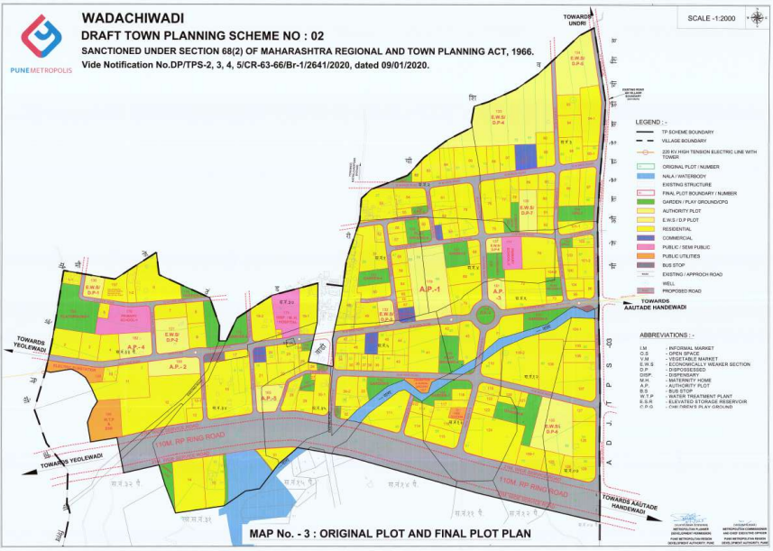
Wadachiwadi TP Scheme Location on Map:
Project Status:
The Draft Town Planning (T.P.) Scheme received sanction on 09/01/2020. Following this, the Arbitrator concluded the hearing with stakeholders, and the Preliminary T.P. Scheme has been formally submitted to the State Government for approval.